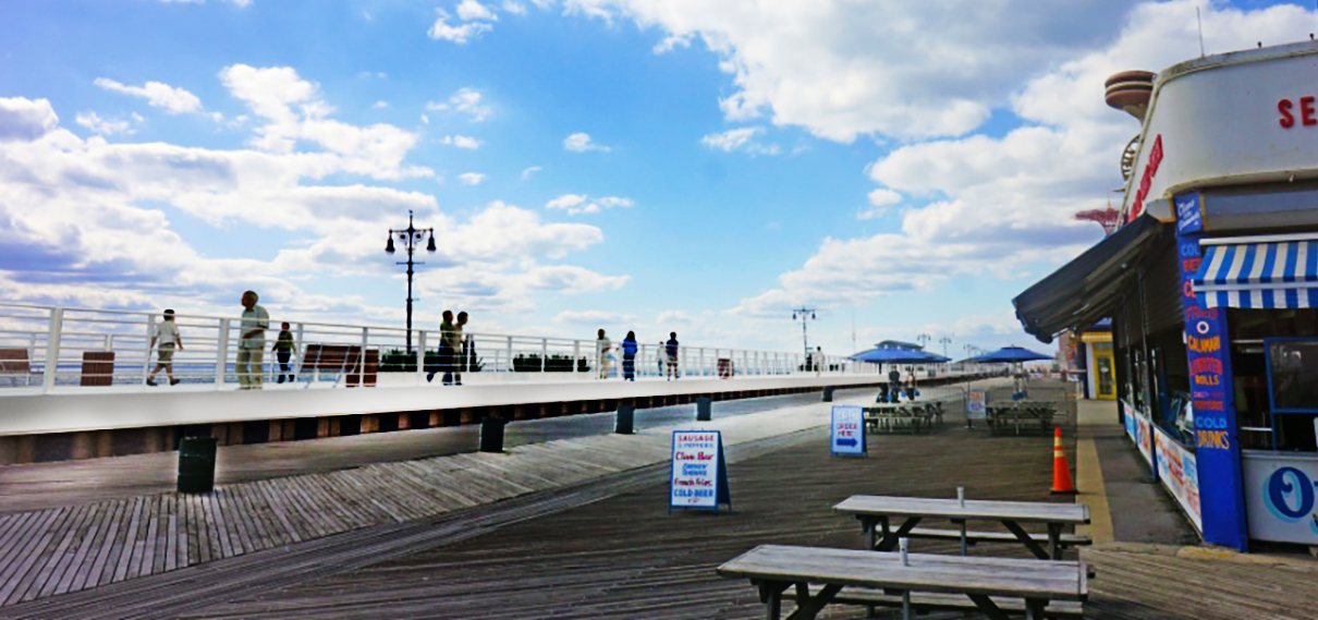
Above: Raised concrete surge barrier on the Boardwalk. Army Corps disclaimers stress that renderings are "initial concepts use for illustrative purposes only and are subject to change." The final plan may be influenced by public comments from community members.
Last September the Army Corps of Engineers released a draft of the New York Harbor Coastal Resiliency Plan (USACE HATS), a complex $52 billion flood control project designed to battle sea level rise and flooding. This plan will have extreme consequences for the shorelines of Coney Island, including the beach, Boardwalk, and Coney Island Creek.
The Army Corps has tentatively chosen "plan 3B" from the NY-NJ Harbor Tributaries study released last September. This proposal recommends flood control "hardscape" such as sea walls, flood walls, and levees to protect Coney Island as well as a massive mechanical tide gate storm surge barrier that would close off Coney Island Creek to prevent flooding.
There are two main projects for Coney Island. On the south side of the island, the Boardwalk would be raised five feet by adding what appears to be a wide concrete walkway. This would act as a barrier to prevent flooding from storm surge. The renderings shown at a January 25th meeting were very sketchy. The concrete barrier would block ocean views for Boardwalk businesses as well as taking up about a third of the Boardwalk.
On the north side, on Coney Island Creek, the plan calls for a mechanical tide gate in Coney Island Creek stretching from Neptune Avenue to Calvert Vaux Park. The tide gate would tie into "sea walls" and into "flood walls" extending along Kaiser Park and Coney Island Creek Park before curving around Sea Gate to connect with the raised concrete Boardwalk at West 37th Street. Detailed renderings of these walls have not been provided.
When this project is completed, Coney Island will undergo an enormous transformation that will impact the neighborhood and local environment for generations to come. Unlike mega-projects of the past, where the public had little input, this time the community might have a voice. The powers that be appear to be listening. A March 31, 2023 deadline to submit public comments about the plan is fast approaching. The Army Corps has promised that all comments will be addressed and added to the public record in June.
Obvious problems with these proposals need to be addressed. The proposed flood walls and sea walls that will run along the parks adjacent to Coney Island Creek will degrade the parks. The barriers should be constructed as living shorelines with raised landscaped levees topped by walkways and bike paths and a restored wetland in the creek. In other words: public amenities. The walls should not be concrete or steel barriers that destroy quality of life in the community. A previous resiliency plan by the City showed beautiful renderings of a raised shoreline project along the creek. The community should advocate for this. The new barriers are to be constructed on public parkland so no private land would need to be appropriated.
The tide gate on the creek is another concern. Tide gates need constant maintenance and can fail in a catastrophic way if not maintained. The City is notorious for not maintaining infrastructure. "Backdoor" flooding caused by overflowing storm sewers on Coney Island Creek can be severe if the gates are closed. The storm sewers drain thousands of acres of upland in Southern Brooklyn during rain events. Passive methods would seem to be more dependable. Another suggestion would be installation of pumps that can drain the creek while the flood gates are closed.
Public input is extremely important. Manhattan seems to be getting more amenities and green space in its part of the plan because of community involvement. In the few weeks we'll be adding more information about what sort of issues need to be commented on.
The Army Corps does not decide what to build. It submits the plan to Congress and then the funding is appropriated to complete the project. Input to federal elected officials might go a long way to getting the proper design.
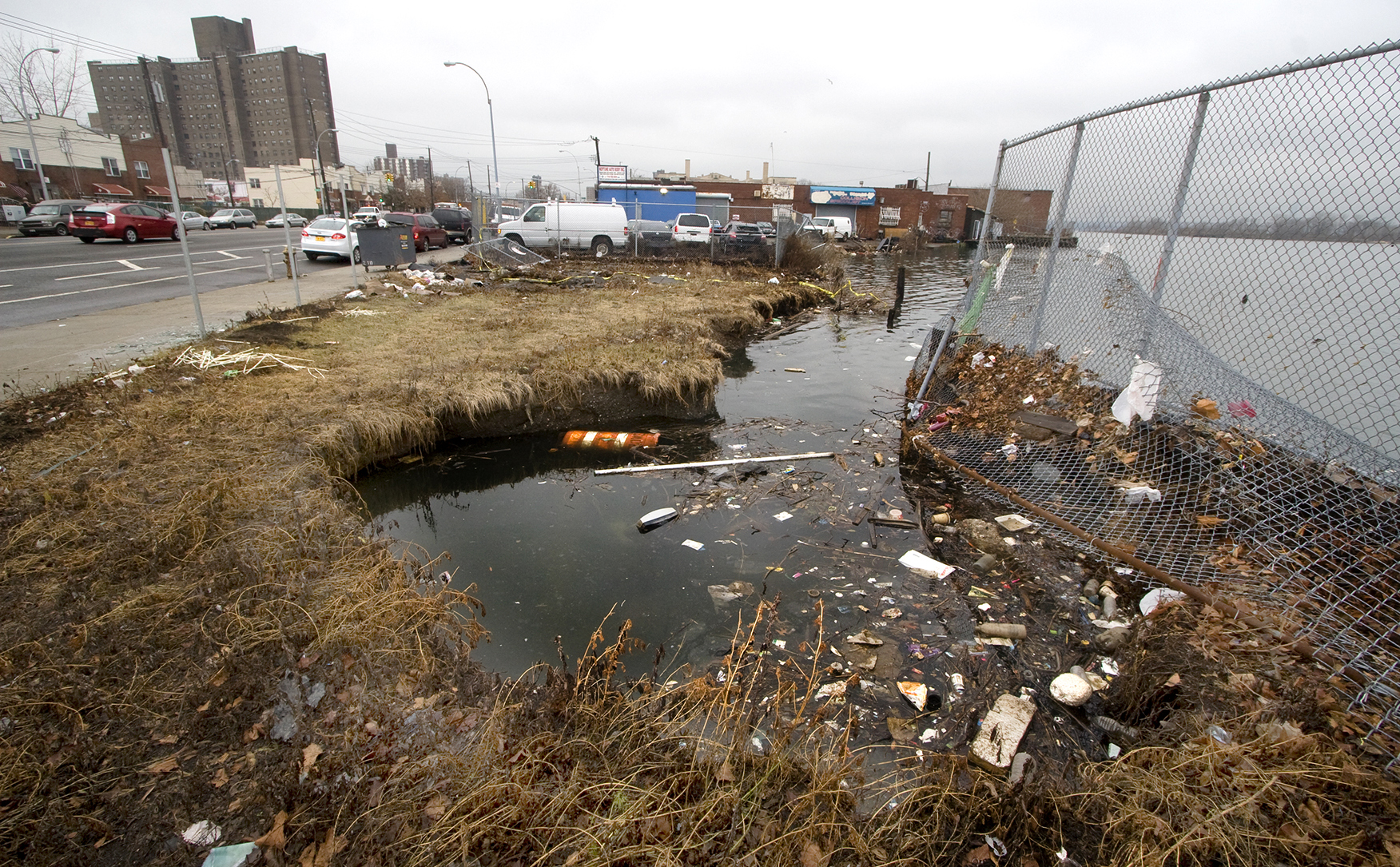
Low point: Coney Island Creek at Neptune Avenue and West 21st Street. Erosion caused by Superstorm Sandy has not been repaired in 10 years. During a king tide the water level in the Creek is higher than the street. Photo by Charles Denson
Public comments are important for the community. The Army Corps HATS plan can be accessed at
https://www.nan.usace.army.mil/Portals/37/NYNJHATS%20Draft%20Integrated%...
The plan is searchable and Coney Island map appears on page 202.
The public is invited to submit comments by mail to:
NYNJHAT Study Team, Planning Division
U.S. Army Corps of Engineers
26 Federal Plaza, 17th Floor
New York, NY 10279-0090
or by e-mail to: NYNJHarbor.TribStudy@usace.army.mil
Please include the project title and the commenter's contact information with submitted comments. Comments are always welcome and will be considered in the study as it continues.
Comments
Coney Island flood prevention
I’m curious as to what measures have been taken in other countries that are a) effective b) affordable and c) attractive. Clearly, there will be some unavoidable impact to the surrounding area but to what extent can that be minimized? The first priority has to be to protect the residents, homes, and businesses of Coney Island. Most of us remember what happened during Hurricane Sandy. Let’s look to experts worldwide, not just in the US.
Friend
Ready whenever you want .... Good luck on the newest season of a great project.
Chuck Reichenthal
Add new comment